


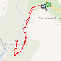
Cascade de Runnes

phimar_2612
User

Length
1.4 km

Max alt
1003 m

Uphill gradient
69 m
Km-Effort
2.3 km

Min alt
926 m

Downhill gradient
68 m
Boucle
Yes
Creation date :
2018-04-16 22:23:36.485
Updated on :
2018-04-16 22:23:36.485
34m
Difficulty : Medium

FREE GPS app for hiking
 SityTrail
IGN / Geographical institutes
SityTrail Plus
The world is yours!
About
Trail Walking of 1.4 km to be discovered at Occitania, Lozère, Pont de Montvert - Sud Mont Lozère. This trail is proposed by phimar_2612.
Positioning
Country:
France
Region :
Occitania
Department/Province :
Lozère
Municipality :
Pont de Montvert - Sud Mont Lozère
Location:
Fraissinet-de-Lozère
Start:(Dec)
Start:(UTM)
553925 ; 4914402 (31T) N.
Comments